

Monitoring the bunds with satellites and sensors
Monitoring the bunds with satellites and sensors
For the past year I’ve been collaborating with Justdiggit and VanderSat (a Dutch remote sensing company), as part of my Master thesis in Watermanagement at the TU Delft, to answer the question if the land restoration projects with bunds in Kenya can be monitored using satellite data. And specifically, using the microwave remote sensing data of VanderSat, measuring soil moisture, surface temperature and vegetation water content, which are the parameters that Justdiggit is trying to positively change with its projects.
The advantage of using satellite data is that the project areas can be monitored on a large scale, which adds the possibility to measure the variability within these areas, and can thus (hopefully) give new insights on the projects (for example, how long lasts the effect of the bunds in time after the rain season?). Furthermore, by measuring soil moisture, surface temperature and vegetation water content, we hope to quantify the impact of the projects after implementation in 2016 (for example, how many water has been retained by the bunds?).

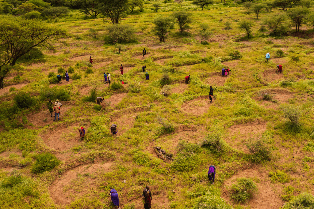
Field visit to plot D in March 2018
In addition to this research, a field visit to the Kuku Group Ranch in Kenya was carried out in March 2018, during the intense rain season, where I stayed at the Maasai Wilderness Conservation Trust, Justdiggit’s local partner. During the fieldwork, I installed soil moisture sensors inside and outside the bunds at different soil layers, which have shown great impact on small scale, with for example soil moisture contents inside the bunds at 40cm depth which were twice as high compared to outside, even three months after the rain season! A great result, and currently, the sensors are still in the field to continue measurements.

Bund filled with water after the first rains in 2018.
Furthermore, a first investigation of optical remote sensing data (ESA Sentinel-2, 10x10m resolution) has shown a great effect as well in terms of vegetation ‘greenness’/healthiness. This was measured using NDVI (Normalized Difference Vegetation Index), which is a parameter that indicates the ‘greenness’/healthiness of vegetation on the ground and varies between 0 (no vegetation) and 1 (healthy vegetation). As a result, the project areas of Justdiggit have shown to be more green after the rain season, compared to the surrounding area. However, a disadvantage of NDVI is that it uses the visible spectrum, which is sometimes completely blocked by clouds.

May 29, 2018: Project areas are more green, one month after the rain season.

June 23, 2018: Even two months after the rain season we see a clear contrast.

April 24, 2018: However, sometimes the area is completely covered by clouds!
By using satellite devices that measure microwaves, we don’t have this issue with cloud cover as microwaves can ‘see’ through clouds! Furthermore, literature has shown that the microwave radiation from soil is directly related to land surface characteristics such as the amount of moisture inside the soil and vegetation at the surface. This makes it in theory ideal to monitor the land restoration projects of Justdiggit, using the soil moisture, surface temperature and vegetation optical depth (measure for vegetation water content) datasets of VanderSat. As the low intensity microwave radiation has large satellite footprints, VanderSat has downscaled their products to 100x100m field-scale resolution, using their algorithm. Furthermore, as the satellites that VanderSat uses, fly over the project areas in Kenya more often than the satellites that measure NDVI, we can monitor these projects almost every day!

The time series of soil moisture, surface temperature and vegetation optical depth, based on passive microwave satellite remote sensing, have not shown clear impact from the land restoration interventions with bunds after implementation in 2016.
Unfortunately, my research has shown that we cannot measure the impact of the projects yet with microwave remote sensing, despite the great effects we saw from the soil moisture sensors and the NDVI satellite images. An explanation for this is that the impact of the projects in Kenya is still too small to be measured with the low intensity microwave radiation and that we would need more bunds or have to wait a couple of years for the vegetation to develop, to monitor the projects with this technique. However, the time series of the data of VanderSat have shown great potential to monitor soil moisture, surface temperature and vegetation water content in the future, as the data has proven to be consistent and has high correlations with ground measurements.
Although I didn’t get the results I hoped for, I learned a lot from my thesis and I’m thankful to Justdiggit and VanderSat for the opportunity I got!
Martijn Mulder
Ps. If you want to read more about my research, check out my report on the repository of TU Delft.
